This paper explores the emergence of regional planning for Berlin in the context of a serious urban crisis and the transformation of balances of power in Greater Berlin around World War I. In that period, public policies and the principles of town planning became very much contested between municipalities, political parties, large private enterprises and experts such as architects, engineers and planners. As a result of a major planning competition concluded in 1910, an inter-municipal legal association (the so-called Zweckverband) was founded in 1912. After the war and the German revolution of 1918, this association was replaced by a completely new administrative concept of a united and centralised municipality of « Greater Berlin ».
This paper starts by briefly addressing some major social and institutional problems that worked as drivers for a very lively and controversial public debate on urban problems and a municipal reform before World War I. It then retraces some crucial discussions amongst leading architects who translated the challenges of the serious urban crisis into planning issues and launched the idea of the so-called « Greater Berlin planning competition » (Wettbewerb Groß-Berlin)[1]. The third part of the paper shows how in the course of the competition a major shift of priorities towards public transport occurred as a result of the interventions of powerful lobby groups. Finally, some key aspects of the new administrative constructions of the Zweckverband of 1912 and the united municipality (Einheitsgemeinde) of 1920 will be discussed. The conclusion reflects on some crucial aspects of urban development and planning pathways in Berlin and Paris in the early 20th century from a comparative perspective.
The urban crisis in an exploding metropolis
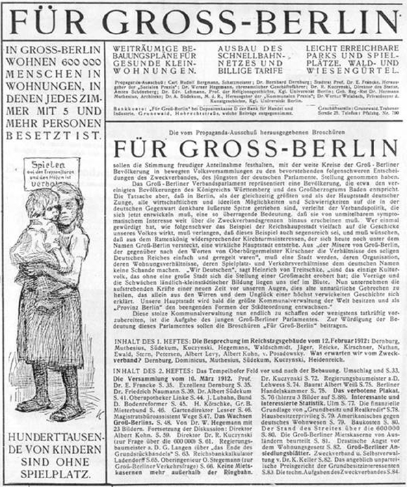
In the first decade of the 20th century, urban growth in the Berlin region reached a historical peak. From 1900 to 1910, the population in the agglomeration grew by one million inhabitants to about four million (2014 : around 3.6 million), nearly closing the traditional gap with the Paris region[2]. This demographic explosion caused major challenges in all fields of urban development and administration, especially on the housing market and in sanitation and public transport. As a result, strong social protests and a growing political opposition led by the Social Democrats and critical intellectuals came up against the established conservative order. The opposition became so strong that the Berlin police commissioner felt obliged to outlaw a poster with a drawing created by the famous artist Käthe Kollwitz. The poster publicly denounced the fact that 600,000 Berliners were living in overpopulated flats with five and more people per room[3]. Furthermore, playgrounds for children and the expansion of affordable public transport were demanded (see Fig. 1).
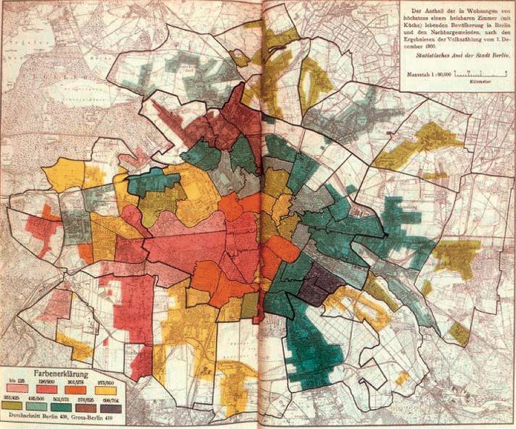
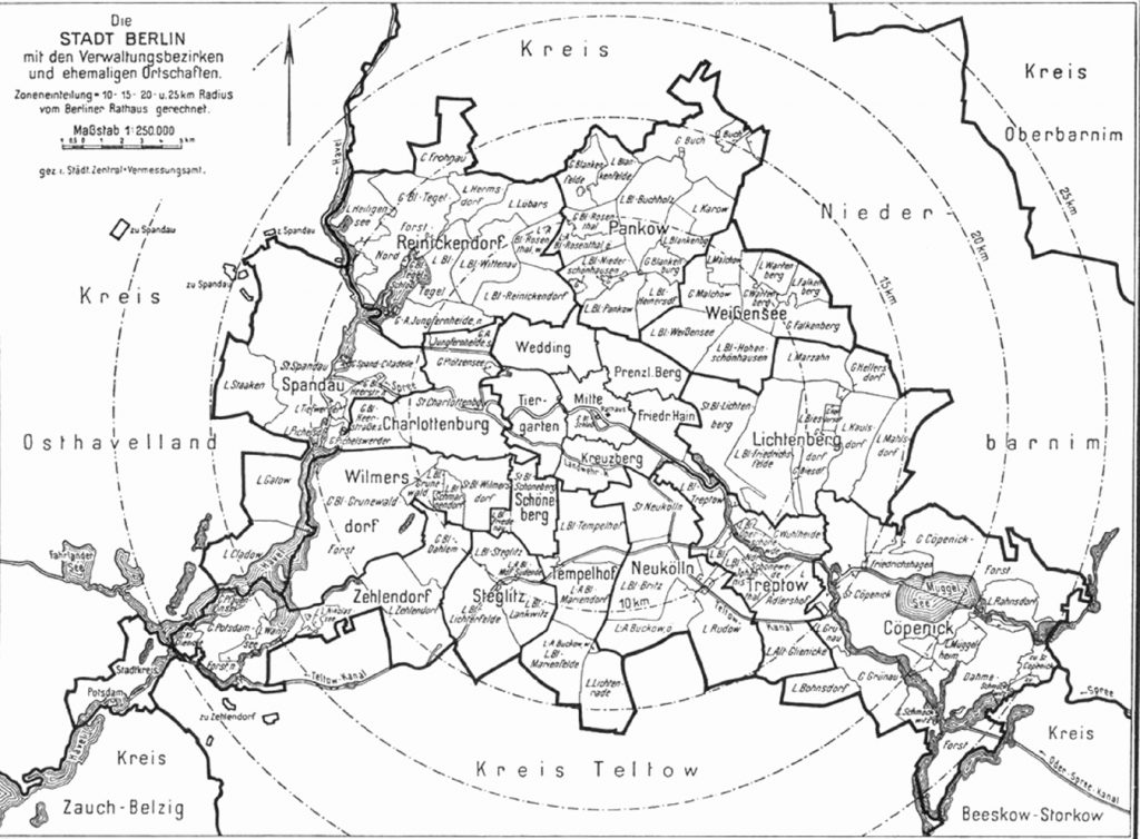
Critics also massively called for an end to administrative fragmentation in the agglomeration. Even representatives of public authorities admitted that Berlin, Charlottenburg (which had around 306,000 inhabitants in 1910) and other large neighbouring cities exclusively followed their specific interests and strongly competed against one another. As a result, the political opposition asked for an administrative reform towards a legally united « Greater Berlin ». At the same time, in the field of urbanism, a broad cultural movement across social classes massively criticised the densely populated city and the hegemony of multi-storey housing (the so-called Mietskaserne) in general (see Fig. 2).
The launching of a major competition for a regional plan
In this context, three prominent architects – driven by the horrifying vision of a steadily growing « urban ocean » (Häusermeer) with more than ten million inhabitants in the near future – developed the idea of a competition for a « large plan » for urban development. Emanuel Heimann, Albert Hofmann and Theodor Goecke launched their project in three lectures given to the Berlin Association of Architects in 1906[4].
In the initial phase of the debate, very different issues were put on the agenda : While Hofmann called for a modernisation of the city centre following the model of the « magnificent transformation » of Paris by Haussmann and Hénard[5], Goecke gave priority to a greenbelt of forests and parks around Berlin, as was discussed in Vienna at that time[6].
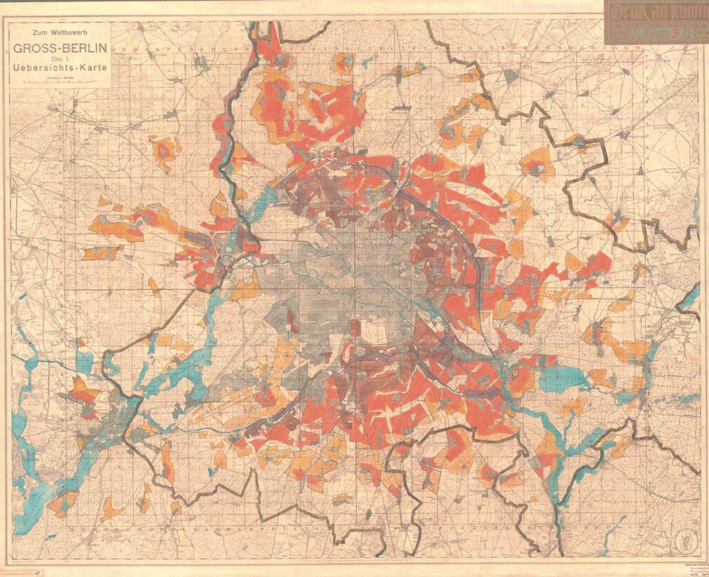
In the following year, 1907, the two major Berlin architect associations set up a preparatory committee and published guiding principles together with a conceptual framework for a competition for a general plan[7]. While preparing these materials, the architects had undertaken preliminary studies on the existing street planning in Greater Berlin, which proved to be uncoordinated and insufficient. This observation convinced urban planning experts from different disciplines that without legal reform no comprehensive planning could be achieved (see also Fig. 3). As a result, from the very beginning, the architects called publicly for an administrative reform, a new inter-municipal institution for planning and a temporary halt to the sale of public land[8].
These were basically political demands that created an uncomfortable situation for the municipalities. On the one hand, they definitely did not want to accept any restrictions on their competences in street planning or their autonomy to sell land. Both activities guaranteed the financial basis of municipal policies. On the other hand, the architects’ initiative had become so popular that the municipalities could not remain uninvolved or prevent the competition from taking place. So, Berlin decided to go ahead and officially launch a call for proposals for the competition on 15 October 1908, and a large number of neighbouring municipalities joined the supervising committee[9]. In order to preserve their profits, several local administrations and the Prussian ministries of the military and forests sold land just before the deadline for proposals to the competition arrived. This indicated that the public actors were not very interested in promoting the competition but preferred to control it and possibly prevent unpleasant consequences[10]. The strong restrictions caused by the existing street planning and the deficit of political acceptance substantially curbed the planners’ chances of developing a comprehensive regional plan in the course of the competition. This can be seen in the proposal of Brix-Genzmer to the competition, whose zoning plan had to make far-reaching concessions to the existing legal status for extended areas (see Fig. 4).
A shift in priorities
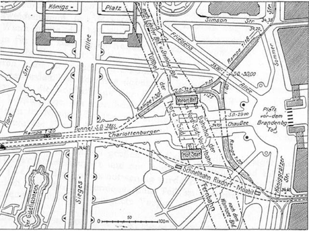
In contrast to the initial proposals of the three architects, the official call for the competition changed the priorities from architectural projects for representative buildings and streets to the planning for open spaces and rail-bound public transport (see Fig. 5 and 6). These issues corresponded much more closely with the interests of the public actors than the first draft that had been presented by the architects.
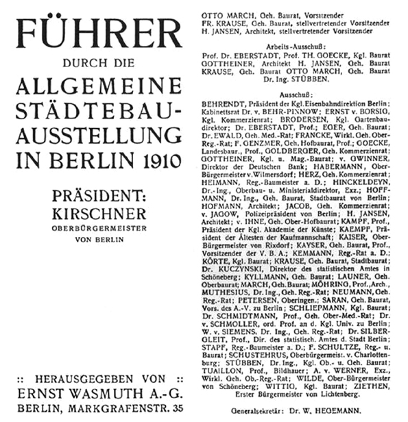
Therefore, during the competition, jury discussions and the following exhibition, the problems of public transport became even more dominant, as noted by Theodor Goecke in his speech at the exhibition opening ceremony. Journalist Werner Hegemann spoke of a « breakthrough in the issue of transport »[11]. But this turn was not so surprising because it had been carefully prepared by the private company Hochbahngesellschaft and other key actors. The company employed two of the most prominent experts in transport planning in Europe – Gustav Kemman and Paul Wittig – who intensively lobbied for a comprehensive planning of rail-bound traffic (« Schnellbahnen »). Parallel to the competition, both of them gave public lectures that drew significant interest, and both also contributed to the prize-winning proposal in the team of Hochbahngesellschaft[12]. The intervention of powerful lobby groups and the strong interest of public authorities culminated in the exhibition that presented the results of the competition. The front page of the official guide to the exhibition indicated the massive involvement of public authorities in the issue by listing the representatives of the administrative bodies and experts involved.
The municipalities agreed with private capital holders on making transport the priority of the competition, as this helped prevent a loss of competences in the street planning and housing sectors. Yet despite their majority in the jury, a battle between architects and engineers escalated there. As a consequence, the official explanatory statement for the decision was considerably delayed, and several jurors refused to sign it. Three of the first four prizes were awarded to the leading experts in transport, while the architects’ candidate and winner of half of the first prize, Jansen, got an extremely negative comment from the jury for his ideas in the field of transport[13]. Journalist Hegemann spoke publicly of a « fight between civil engineers for transport and urban planners in the traditional sense, which culminated in the debates on the Greater Berlin competition, the exhibition and the following public lectures »[14].
Hegemann also popularised the results of the competition by organising the exhibition and through sizeable documentation on both events, which became a milestone in the debate on urban design in Germany and beyond[15]. The main message that he was propagating very successfully was that within the few years around 1910, the ideal vision of urban design for Berlin had changed : While in 1906, in launching the initial idea of the competition, the architect Albert Hofmann had strongly promoted the vision of the compact city of Paris as a role model for Berlin, Hegemann condemned the Paris model and successfully declared the decentralised urban fabric of Greater London as the new role model[16].
The founding of a special inter-municipal association « Zweckverband » 1912
However, the projects that the planners put forward in their proposals to the competition were never carried out. Resistance was particularly strong against any substantial housing reform. Instead, a special purpose association was founded by the Greater Berlin municipalities and counties in 1912, the so-called Zweckverband Groß-Berlin. Its major task was to coordinate the local public planning in the fields of street building, green spaces and transport.
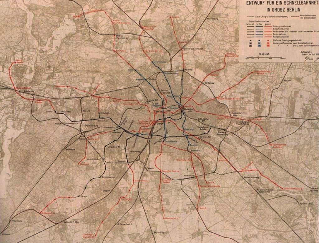
On the one hand, the cooperative structure and limited executive competences of the association made it a weak organisation that did not achieve very much in practical terms. On the other hand, the Zweckverband brought together a number of highly-qualified experts – including Martin Wagner, Fritz Beuster and Erich Giese – who had the chance to elaborate scientifically-based concepts and practical programmes for regional planning[17]. This was especially true for public transport planning, which was designed by Erich Giese and published in 1919 (see Fig. 8). As early as 1915, the Zweckverband also succeeded in buying extended areas around Berlin, mainly forests, from the Prussian ministries and legally preserved their status as forests (Dauerwald).
In a more general sense, the limited competences of the Zweckverband were caused by an inefficient compromise between social reformers and financial and political interests of the leading groups of the German Second Empire on the eve of World War I. But it was able to generate ideas and concepts that stimulated the broad debates on housing and social reform and became very powerful after World War I. In the course of the German revolution of 1918-19, which fundamentally changed the general political framework of urban governance, political parties and governments showed strong interest in the concepts that the Zweckverband had developed.
After the Revolution of 1918 – the groundbreaking administrative concept of « Greater Berlin »
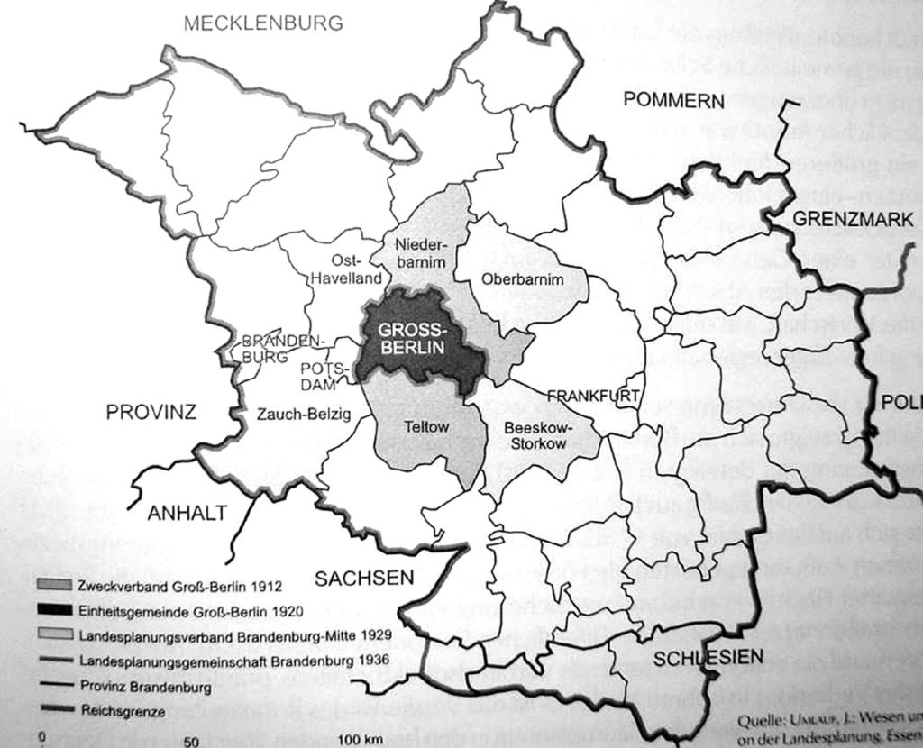
In 1920, the Prussian parliament passed the groundbreaking law on the building of the new City of Greater Berlin. Although several proposals were presented to the Prussian Parliament to expand the Zweckverband model, the majority considered this to be an inefficient construction[18]. As a result of controversial debates in 1920, eight cities and 59 villages were brought together in the new City of Greater Berlin that was governed by one major and his municipal board[19]. The motive of concentrating financial autonomy in the hands of a single individual was a key argument in favour of a united municipality (Einheitsgemeinde) instead of an inter-municipal cooperative solution (Zweckverband or Gesamtgemeinde)[20]. In administrative terms, this reform made Berlin the largest city in the world and it was regarded as a model for centralised administration and planning of metropolitan areas in the contemporary international debate[21].
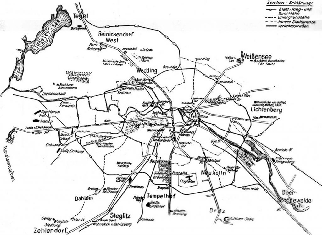
A comprehensive building law passed in 1925 (Bauordnung 1925) put an end to the Berlin Mietskaserne and provided a legal framework for the pioneering settlements of modern architecture such as Hufeisensiedlung Britz or Onkel Tom’s Hütte and others (which in 2003 were declared UNESCO cultural heritage sites). In 1929, a municipal law on open spaces in Greater Berlin (Generalfreiflächenplan 1929) completed comprehensive legislation on urban development and planning[22]. Public authorities also undertook strong efforts to publicise the achievements of the newly-established administration of Greater Berlin and to reshape the mental maps of Berliners via public propaganda. New journals such as Das Neue Berlin discussed a wide range of urban problems and public policies and praised the efforts and showrooms of modern urbanism, including the famous settlements, new warehouses, etc. A map presenting these architectural highlights provided some orientation on the new spatial order and met with enthusiastic approval from the leading architect Bruno Taut.
This paper has endeavoured to show that the issues of planning and administrative reform in early 20th century Berlin were very much shaped by interests of political power and economic lobby groups. In this context, urbanism developed as a science and was increasingly regarded as an instrument to govern the urban crisis. The new scientific discipline was implemented at German universities, and representatives of the Technical High School of Charlottenburg (later to become the Technical University of Berlin) played an important role in the public debates reported above.
For a comparative debate on the pathways of Berlin and Paris in the early 20th century, three key aspects have to be considered : Firstly, one can observe in the early 20th century a short period of convergence between Berlin and Paris with regard to population growth and public debates on urban reform. After 1920, development diverged again throughout the 20th century. Secondly, the two pathways of urbanism in the two capitals were fundamentally shaped by public policies, which considerably differed from each other. Key projects such as the Haussmann and Hobrecht planning programmes for Paris and Berlin, as well as Prussian building laws, served as powerful tools to govern the urban societies and the patterns of socio-spatial development. Thirdly, as a result, the political topographies of the two regions differed substantially : Very generally speaking, one can identify a bourgeois suburban landscape in Berlin instead of a banlieue rouge and proletarian dominance in a number of inner quarters of the city with their extended areas of proletarian multi-storey housing (Mietskasernen). These different demographic, socio-spatial and political patterns, together with other economic and administrative trends, have very much influenced the two divergent pathways that urban policies and strategies of governance showed in Berlin and Paris in the early 20th century.